

Roadbook
Il tuo percorso
Nome itinerario - se costruito Paese Partenza - Paese Arrivo (modifica percorso)
voto degli utenti: 
Legenda
 |
Asfalto |
 |
Pavimentazione |
 |
Sterrato |
 |
Sentiero |
 |
0-5% |
  |
+/- 5-10% |
  |
> +/- 10% |
Download cartina topografica dettagliata
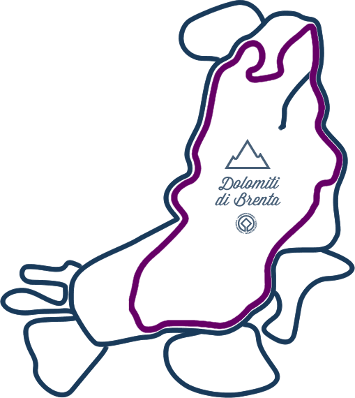
Dolomiti di Brenta Bike - ROADBOOK - versione 1.0 (set 07) Campo Carlo Magno - B001
| nr | WP | km | km parz | alt | simb | luogo | direzione | fondo | pendenza |
|---|---|---|---|---|---|---|---|---|---|
| 0 | B001 | 0 | 0,750 | 1654 |
 |
Campo Carlo Magno | a sinistra, in salita |
|
|
| 1 | B002 | 0,750 | 0,680 | 1730 |
 |
bivio per M.ga Montagnoli | dritto per Rif. Graffer |
|
|
| 2 | B003 | 1,430 | 1,580 | 1763 |
 |
bivio per M.ga Vagliana | dritto per Rif. Graffer |
|
|
| 3 | B004 | 3,010 | 0 | 1960 |
 |
bivio per M.ga Boch | a sinistra per Rif. Graffer |
|
|
| 4 | B004-B010 | 3,010 | 0 | TRATTO IN VIA DI DEFINIZIONE | |||||
| 5 | B010 | 3,010 | 0,230 | 2064 |
 |
incrocio strada servizio pista da sci | a sinistra, in salita lungo la pista |
|
|
| 6 | B011 | 3,240 | 0,090 | 2103 |
 |
Monte Spinale | dritto, in discesa, lungo la strada sterrata |
|
|
| 7 | B012 | 3,330 | 1,050 | 2090 |
 |
bivio strada sterrata | dritto, lungo strada più battuta |
|
|
| 8 | B013 | 4,380 | 2,720 | 1955 |
|
M.ga Fevri | dritto, in discesa, lungo la strada sterrata |
|
|
| 9 | B014 | 7,100 | 0,150 | 1569 |
 |
incrocio | a sinistra, in discesa |
|
|
| 10 | B015 | 7,250 | 0,460 | 1550 |
 |
bivio strada asfaltata, strada sterrata | a sinistra, in salita, lungo strada asfaltata |
|
|
| 11 | B016 | 7,710 | 0,070 | 1520 |
 |
Madonna di Campiglio, bivio | dritto |
|
|
| 12 | B017 | 7,780 | 0,230 | 1516 |
 |
Madonna di Campiglio, bivio | dritto, in discesa |
|
|
| 13 | B018 | 8,010 | 0,400 | 1495 |
|
Madonna di Campiglio, bivio | a sinistra, lungo strada pianeggiante |
|
|
Tours
![]()
tour
Dolomiti di Brenta Bike Expert
177km | 7700m dislivello | 3+gg
A trip with plenty of uphills and off-road sections, technical downhills and challenging gradients, the perfect choice for most intrepid and expert mountain bikers.
Show all details: information, elevation gain, map and gpx tracks!
MAPPA / GPX DOWNLOAD / DESCRIZIONE
Organize with us your bike tour. It's easy: you need 3 days, a little bit training and by ebike you can ride it without problem!
tour
Dolomiti di Brenta Bike Country
136km | 4600m elevation gain | 3+days
Il mountain bike tour più leggero, ma non senza fascino: esplora i tranquilli borghi del fondovalle, pedala in sicurezza sulle piste ciclabili. Un tour quasi per tutti.
Vedi i dettagli se ancora non li conosci: tutte le informazioni, il profilo altimetrico, naviga la mappa, scarica la traccia per il tuo dispositivo!
MAPPA / GPX DOWNLOAD / DESCRIZIONE
Organize with us your bike tour. It's easy: you need 3 days, a little bit training and by ebike you can ride it without problem!
tour
Dolomiti di Brenta Bike Explorers
Are you an extreme rider? Add a Dolomiti di Brenta Bike Explorer tour to your holiday!
Choose between your Explorer Bike Tours, and explore the unique territory of the Brenta Dolomites, from the valley floor to the foot of the glaciers, between meadows and fields, farms and ravines!
If you have choosen your Explorer tour and you are ready to start, organize with us your personlised holiday. Add a day for every Explorer tour!
Val Rendena
DBB Explorer Val Borzago
42km | 2170m uphill | 7h
Giudicarie Centrali
DBB Explorer Val di Breguzzo
39km | 1700m uphill | 5h
Comano Valle Salus
DBB Explorer Monte Casale
55km | 2500m uphill | 8h
Molveno Andalo Paganella
DBB Explorer Monte Gazza
46km | 2100m Höheunterschied| 6h
Val di Non
DBB Explorer Val di Tovel
26km | 770m uphill | 4h
Val di Sole
DBB Explorer I Masi da Mont
25km | 1100m uphill | 4h
Plan
![]()
Plan
your DBB
Have already planned the Dolomiti Brenta Bike tour? If you haven’t you can rely on us! Choose the self-guided MTB tours that better suits you and we’ll book hotels, luggage transfer and provide you with detailed maps and all the hints to fully enjoy the tour!
Do you prefer to organize yourself the tour? Here you’ll find all the useful information and suggestions on how to approach the tour: equipment, bike, accessories, clothing as well as organised tours with MTB guide.
ASK TO STAFF
DIY BIKER
Plan
Hospitality
Val Rendena Altopiano della Paganella Val di Non Val di Sole Valli Giudicarie Terme di Comano €€€ » € € « €€€
GRAND HOTEL MOLVENO
![]()
![]()
![]()
from € 100
 MOLVENO
DOLOMITI APART
from € 75.43
BLEGGIO SUPERIORE
RESIDENZA ALBA
from € 69.57
MOLVENO
CASARIGA
from € 68.57
COMANO TERME
FONTANELLA
![]()
![]()
![]()
from € 65
MOLVENO
MIRALAGO
![]()
![]()
![]()
from € 56.43
MOLVENO
CASTEL FERARI
![]()
![]()
from € 55
TUENNO-VILLE D'ANAUNIA
TRENTO
![]()
![]()
![]()
from € 45
SELLA GIUDICARIE BREGUZZO
![]()
Restaurants and services
Restaurants and services
![]()
Social
![]()


